Nestled in the Blue Ridge Mountains in Northern Virginia, the Shenandoah National Park boasts 200,000 acres of dense forests, extensive meadows, 500 miles of trails, cascading waterfalls, and the famous Skyline Drive views.
Whether you are just there to enjoy the views, are heading out on a week-long Appalachian Trail adventure, or are just visiting for a day from Washington, D.C., this National Park features something for everyone.
History of Shenandoah National Park
This Native land showed the first traces of human touch over 8,000 years ago. It was an abundant land for gathering food, sourcing stones and wood for tools and trade, and of course, for hunting. European colonizers made their way to the Shenandoah Valley around the 1700s and then, shortly after, began moving to the area. Fast forward to the late 1800s, the region became more urban, and vacation resorts became popular. Later, the park was established in the National Park Service (NPS).
Points of Interest at Shenandoah
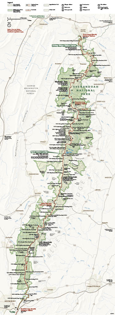
For those with limited time at the park, the number one non-physical activity at the park is driving on the gorgeous 105-mile Skyline Drive. This vista-heavy car ride takes approximately three hours, edges the Blue Ridge Mountains, and is the only public road in the park.
To discover the history, geology, anthropology, and ecosystems of the park, visit one of the enriching exhibits on-site or virtually. The Dickey Ridge Visitor Center offers a movie, an interactive exhibit, and an interesting topographic map of the park. The Massanutten Lodge was home to the co-owner of Skyland Resort, a meeting place for women back in the Roaring 20s.
The Byrd Visitor Center showcases the stories of Shenandoah's establishment and development, the CCC's work in the area, and the lesser-known story of the park's desegregation in the 1930s and 40s. Lastly, the Rapidan Camp actually used to be the summer vacation spot for President Herbert and First Lady Lou Henry Hoover. Visit the refurbished home and learn more about Hoover's rocky time as president.
Map of Shenandoah National Park Hiking Trails
RELATED: Colors Blend Beautifully at Green Lakes State Park
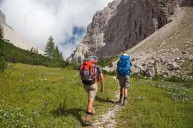
Hikers will appreciate having over 500 miles of trails to explore. From short hour-long hikes to waterfall hikes to longer all-day hikes to family-friendly hikes to remote backpacking hikes in the backcountry...you can pick what is best for you. The park spans from the north end Front Royal Entrance Station (milepost 0) to the Rockfish Gap Entrance Station in the south. Stop for lunch at one of the picnic areas for a relaxing break from your hikes.
Popular waterfall hikes include Hazel River Falls, Rose River Falls, meandering through Whiteoak Canyon to the lower or upper falls, Lands Run Falls, and the highest falls in the park, Overall Run Falls. Another frequented trail in the area, Dark Hollow Falls, follows a stream to a gorgeous waterfall.
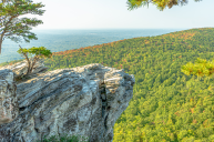
Stony Man, Marys Rock Summit, and Hawksbill Mountain Loop offer some of the best views of Shenandoah Valley and Massanutten Mountain. Walk to the top of Old Rag Mountain via the Berry Hollow parking area for an easier way to summit Old Rag.
Take a hike on the Appalachian Trail and look out for wildflowers and birds with a stroll on Pass Mountain Loop. Bearface Viewpoint presents a great view of Shenandoah Valley without the rock scramble that many more challenging hikes present.
To witness the mountain laurel blooms in all of their glory, take the Sugarloaf Loop. When you travel on the Elkwallow Wayside, you will discover natural beauty along a picturesque creek in the Knob Mountain area of the park.
Family-friendly hiking trails include Fox Hollow Trail, Sneed Farm Loop, and Fort Windham Rocks. An epic view of the valley, also kid-friendly, can be found on the shorter hike to Blackrock Summit.
The park's website features great trail maps to discover and dive into the 500 miles of trails in more detail.
Camping at the Park
For overnight stays at the park, including Big Meadows Campground, Mathews Arm Campground, Loft Mountain Campground, Lewis Mountain Campground, and backpacking in the backcountry. If you are backpacking, it is recommended to purchase a topographic map at one of the visitor centers or online from the Shenandoah National Park Association or the Potomac Appalachian Trail Club (PATC).
Have you hiked the Appalachian? Share your trip on our Wide Open Roads Facebook!