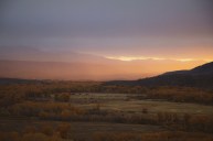
Located in a desolate part of Texas near the border of New Mexico, this National Park offers a hidden oasis in the middle of the Chihuahuan Desert. Featuring the highest point in Texas at 8,749 feet, Guadalupe Peak, this National Park sits just under two hours from El Paso in a small town called Salt Flat, Texas.
This diverse park spans over 85,000 acres and is known for its interesting white Salt Basin Dunes, ecologically rich grasslands, and its mountain range composed of the fossilized reef. Now a part of the National Park Service system (NPS), the land belongs to the Native Kónits?...?...íí gokíyaa (Cúelcahén Ndé - Lipan Apache) and Mescalero Apache tribes.
Guadalupe Mountains National Park Map & Trail Guide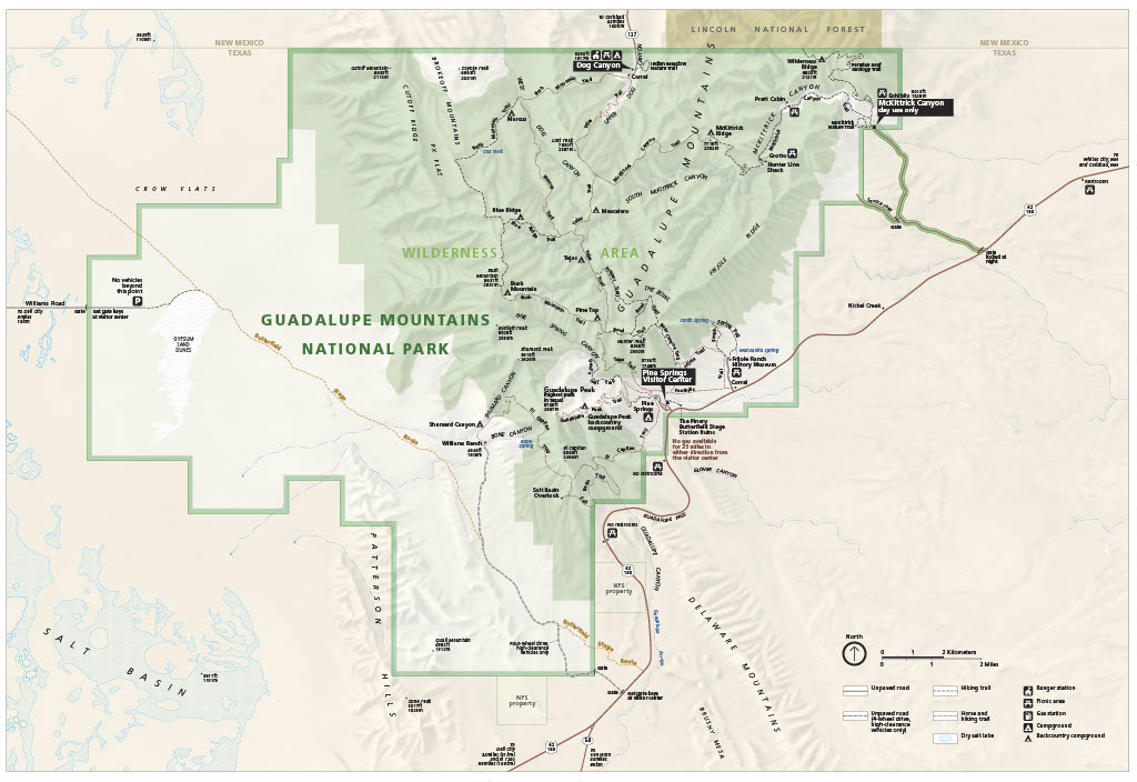
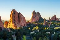
Hikers flock from all over the region to enjoy the vast array of hiking trails this National park offers. Approximately 80 miles of trails ranging from leisurely strolls to challenging summits provide a trail that will fit anyone's needs. Unless you are heading out into the backcountry for a backpacking adventure with a permit, then there are five main trailheads to embark on your hike from. Check out the trail map and trail description below.
Pine Springs Trailhead
Guadalupe Peak Trail
Head to the "Top of Texas" on this very steep, challenging but worth-it hike. The peak trail has 3,000 feet of elevation gain with a round-trip distance capping off just under 8.5 miles. It is best to plan for six to eight hours total and avoid the trail during storms or high winds.
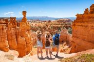
Devil's Hall Trail
On this 4.2-mile round trip hike, you will trek through the old creekbed of Pine Springs Canyon, then head up the Hiker's Staircase to the final haul through the Devil's Hall. This trail is rocky, has minimal elevation gain, and takes you through many plant ecosystems, including ponderosa pine and maples.
The Bowl
You will be surprised at the dense forest present in the Chihuahuan Desert. If you can make the ascent 2,500 up on The Bowl hike, you can witness a lovely coniferous forest of Douglas fir and pine trees. This one starts at the Pine Springs Campground along the Frijole Trail and Bear Canyon Trail to the top until you make a left on the Bowl Trail. After that, head to Hunter Peak before your final descent on the Tejas Trail. This strenuous hike is 9.1 miles for an approximate total of eight to ten hours.
The Overlook Trails: El Capitan/Salt Basin
This moderate trail is 11.3 miles round trip and usually takes up to eight hours to complete. It winds through the desert to the base of El Capitan on the southern end of the mountains. You will follow signs for the El Capital & Salt Basin Overlook Trails. You can either return back to the Pine Springs campground on the El Capitan Trail, or you can go an additional 4.7 miles to the Williams Ranch Historic Site.
Dog Canyon Trailhead
Lost Peak
This moderately-rated trail is 6.4 miles back and forth. It winds through an open meadow and into the canyon bottom along the Tejas Trail. Take in the greenery of pines, junipers, and bigtooth maples before you begin a 1,540-foot elevation gain towards Lost Peak.
Marcus Overlook
The Marcus Overlook Trail is a 4.5-mile moderator hiking trail that follows the Bush Mountain Trail to Manzanita Ridge. Make sure to take in the view of West Dog Canyon and then return on the same route back.
Indian Meadow Nature Trail
If you are looking to learn about the Native History and culture of the area, take the Indian Meadow Nature Trail, a leisurely 0.6-mile stroll.
Frijole Ranch Trailhead
RELATED: 5 Oregon Road Trips for a Weekend Getaway
Smith Spring Trail
An excellent walk for wildlife spotting, the 2.3-mile round-trip Smith Spring Trail meanders through a shady haven of Smith Spring before you reach the sunnier Manzanita Spring. You can see the remnants of two wildfires from the early 1990s.
Manzanita Spring
To only reach Manzanita Spring, you leave from the trailhead right behind the ranch house and take the 0.2-mile paved trail to this lovely waterhole. Just do not disturb the water in any way as it serves as a lifeline for animals in the area.
Frijole/Foothills Trails
For more solitude, take the road less traveled on this connecting loop on the Frijole and Foothills trails between Pine Springs Campground and Frijole Ranch.
Headquarters Visitor Center Trailhead
The Pinery Trail
This easy-rated 0.75-mile paved trail goes through the old Pinery Station ruins, which used to be a frequent stop on the original 2,800-mile Butterfield Overland Mail Route. This is one of the rare paths in the park that is both pet and wheelchair accessible.
McKittrick Canyon Trailhead
https://www.instagram.com/p/CN0_TxugcmT/?utm_source=ig_web_copy_link
McKittrick Canyon Nature Trail
Discover the Permian Reef geology and micro-ecosystems that thrive along this 0.9-mile moderate trail. Taking less than an hour to complete, this trail features exhibits that discuss plant life, wildland fire, and other interesting facts about the area.
McKittrick Canyon Trail
Grab a guide book from the McKittrick Canyon Contact Station or the Headquarters Visitor Center to use while along this 4.8-mile round-trip trail. Ideal for seeing the changing fall foliage, the McKittrick Canyon Trail takes you through the desert, the canyon woodlands to the Pratt Lodge, the Grotto picnic area, and the Hunter Cabin.
Permian Reef Trail
This 8.4-mile round-trip strenuous trail boasts 2,000 feet of elevation gain. Also, it has a geology guide available at the park's Headquarters Visitor Center. When you reach the top, enjoy fabulous views of McKittrick Canyon from the top of Wilderness Ridge.
Important Information
The park and its features are typically opened 24 hours a day every day of the year, but check here for specific information.
The entrance fee for those 16 and older is $10 per person. An annual pass to Guadalupe Mountains National Park for up to four adults in a private vehicle each visit is $35 and can be purchased at the Pine Springs Visitor Center (open seven days a week from 8:00 AM to 4:30 PM). While you are in the area, we suggest also visiting Carlsbad Caverns National Park. Head to https://www.nps.gov/gumo/index.htm for more information.
All hikers are required to follow posted guidelines and restrictions to maintain the integrity and safety of the park.
Planning to visit this Texas national park? Share your experience at our Wide Open Roads Facebook!