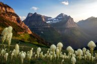
Glacier National Park is a hiker's paradise, a true gem of the National Park Service system. When the region, home to different Indigenous tribes, was signed by President Taft in 1910 to make it the 10th National Park, there were 150 glaciers. Now, there are less than 25 and sadly, they are shrinking at a rapid rate.
Even with this alarming statistic, hikers and explorers flock by the thousands to witness the beauty of the region in real life. Nestled in Montana's Rocky Mountains, this 1,583-square-mile wilderness area features monumental peaks and valleys that stretch past the Canadian border.
Best Hikes in Glacier National Park
Glacier National Park offers incredible outdoor opportunities, including over 700 miles of trails, hidden alpine lakes, ample backpacking treks, cycling, and catching glimpses of rare wildlife. While it is extremely hard to categorize and rank the best hikes in Glacier, we are going to attempt to highlight the best hiking trails, including longer backcountry hikes, day hikes, easy hikes, and more challenging hikes with the most stunning views.
As far as breaking the park down into hike-able sections, the primary hiking areas of the park include Lake McDonald, Many Glacier, North Fork & Goat Haunt, St. Mary (including Logan Pass), and Two Medicine. For organization's sake, we are going to break our favorite hiking trails into these sections.
Lake McDonald Area
Avalanche Lake: Known as one of the most visited day hikes in the park, the Avalanche Lake Trail is a one-way, 2.3-mile trail with an elevation gain of approximately 500 feet. The trailhead is located at the Avalance Picnic Area and the journey begins at the boardwalks of the Trail of the Cedars Nature Trail. You then follow Avalanche Creek through beautiful forests until you arrive at the jaw-dropping views of Avalanche Lake. This day hike does get extremely busy, so it is best to go early in the morning to avoid crowds.
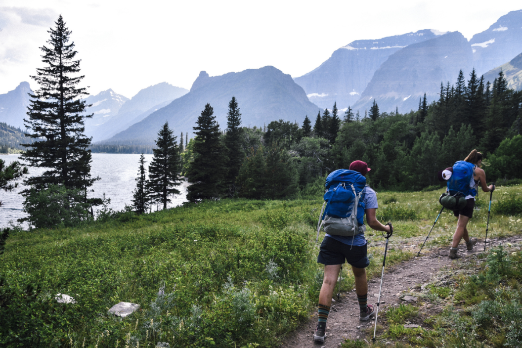
Two Medicine Area
RELATED: 23 Hiking Puns That'll Be "Hill-arious" at the Summit
A crowd favorite for a great hike in the Two Medicine Area is the 7.6-mile Pitamakan Pass trail. With an elevation gain of 2,400 feet, this trail is no joke. Pair this hike with the Dawson Pass hike for a combined loop trail. Both trails begin at the North Shore Trailhead and take you from the main Two Medicine Lake area to smaller alpine lakes with incredible views.
Many Glacier Area
The Many Glacier Area of Glacier National Park is quite arguably the crown jewel of the park's hiking trails. If you only have a few days to check out one area of the park, the Many Glacier portion is definitely a great option.
Grinnell Glacier
A total of 10.6 miles round trip (5.3 miles one-way), the Grinnell Glacier Trail takes all of the best of the park (glaciers, wildflowers, wildlife, alpine lakes, valleys, and stunning views) and combines it into a hike that you may rank up there in the top 10 hikes you have ever done! The trek starts along the Swiftcurrent Lake Nature Trail until you veer right to walk alongside Lake Josephine.
With 1,600 feet of elevation gain, this trail features the Grinnell Glacier Overlook (or viewpoint). You can combine this hike with the Grinnell Lake Trail, adding 3.6-miles each way to round out to just under 20 miles.
Cracker Lake
One of the lesser-traveled alpine-lake hikes in the Many Glacier Area, Cracker Lake presents icy blue waters surrounded by mountains, alpine meadows, and one of the best places for bear sightings. With a distance of 12.8 miles and an elevation gain of 1,400 feet in grueling switchbacks, Cracker Lake is not for the faint of heart. The views are incredibly worth it, though!
Iceberg Lake
RELATED: The Legend of Bash Bish Falls: Massachusetts Haunted Waterfall
Another of the best hikes in the Many Glacier Area is the hiking trail to Iceberg Lake. A 10-mile round trip is said to be one of the "easiest" longest hikes you will do. The views remain breathtaking throughout the hike, while the elevation gain of 1,200 feet is lovingly spread out over 5 miles. If you want to add an extra challenge to the Iceberg Lake hike, add the Ptarmigan Tunnel Trail to your itinerary. If you start with the Tunnel Trail, you can finish with the easier Iceberg Lake Trail for a well-rounded 15-mile loop.
Swiftcurrent Pass
For a super challenging, yet rewarding all-day adventure, consider hiking Swiftcurrent Pass. This 13.6-mile out-and-bike hike gains 2,300 feet in elevation and is for advanced hikers only. The trailhead begins at the Swiftcurrent Motor Inn and uses the same path as Redrock Falls. After you see Redrock Falls, you begin ascending thousands of feet for some of the best views of the mountain peaks and surrounding mountains in the entire park.
St. Mary Area & Logan Pass
https://www.instagram.com/p/CHx_jE2Aw_V/?utm_source=ig_web_copy_link
Highline Trail
One of the prettiest and most-loved trails of the entire park is the famous Highline Trail, which starts near the Logan Pass Visitor Center and meanders 7.6 miles to the legendary Granite Park Chalet. A relatively flat trail compared to others in the park, the Highline Trail follows the Continental Divide through mind-blowing views of glacier valleys, mountain peaks, and views you did not even know could exist (besides on Instagram).
Mountain goat sightings are plentiful here, despite the crowds. Once you arrive at Granite Peak Chalet, you can purchase a snack or beverage, and find your way back from where you came. One of the most popular ways back is the steep, 4.2-mile descent on the Loop Trail to the Going-to-the-Sun road and then riding the shuttle back to Logan's Pass. Or you can turn around and take the same route back to the trailhead.
St. Mary Falls
A great option for an easier day hike is taking the St. Mary Falls Trailhead for a 3.6-mile, out-and-back hike to two beautiful waterfalls, St. Mary Falls and Virginia Falls.
Siyeh Pass
Another Glacier bucketlist for the advanced hikers in your life, Siyeh Pass is an 8.9-mile round-trip hike with 2,090 feet in elevation gain (making it one of the highest trails in the entire park reaching over 8,000 feet elevation). Bear sightings are frequent here in the Preston Park Valley, so stay alert and be prepared with your bear spray.
Siyeh Pass has multiple trailhead options, including Going-to-the-Sun Road, at Piegan Pass or Sunrift Gorge. If you are looking for a less crowded but almost as beautiful trail as the Highline Trail, this may be your best bet.
Hidden Lake
Starting at the Logan Pass Visitor Center, the Hidden Lake Overlook and Hidden Lake Trail (also known as the Hidden Lake Nature Trail) is one of the most popular hikes in Glacier has it is shorter, less challenging, and still offers jaw-dropping views. On this hike, you will pass by the famous Hanging Gardens, and usually see wildlife such as bighorn sheep and marmots. If you want to add the extra challenge, from the Hidden Lake Overlook, you can hike further down to the Hidden Lake itself. The parking lots are usually always full at Logan Pass so the shuttle is highly recommended here (unless you can get on the trail in the wee hours of the morning).
North Fork & Goat Haunt
This section of the park also has a wonderful range of hikes for all types of adventures. Favorite hikes in this area include shorter 1 to 3-mile hikes in alpine meadows (Covey & Hidden Meadows) to 4 to 12-mile hikes to crystal-blue lakes (Logging, Lower Quartz, Lake Janet & Lake Francis) to the 2-mile round-trip Rainbow Falls hike.
Going-to-the-Sun Road
You cannot call out the most popular hikes in Glacier National Park without first talking about one of the main attractions in the park — Going-to-the-Sun Road. This scenic byway traverses fifty miles from east to west, connecting the Apgar Area to the St. Mary Area with lots of scenic viewpoints, hiking trails, and other sights in between. The highest point of the road is Logan Pass, which routinely fills to capacity (this is when the park's shuttle system is a great alternative to driving your own car). Be sure to check out all the helpful information for driving and touring Going-to-the-sun Road, as there are required tickets and some alpine sections of the road are only open for short periods of time in the summer.
Important Information
https://www.instagram.com/p/CR6dC3jponQ/?utm_source=ig_web_copy_link
Before heading out on any hikes, always check the Glacier National park Trail Status tool. Follow all signage and warnings posted, check in at the ranger station and let them know where you are hiking if possible, and always stay alert for wildlife. Common wildlife at Glacier includes mountain goats, bighorn sheep, grizzly bears, and lots of birds!
For more adventures, follow along at our Wide Open Roads Facebook!